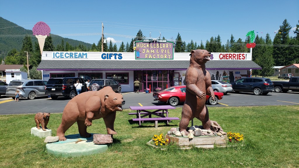
There isn’t really any way you can follow-up the magnificence of Yellowstone, but we were hopeful Glacier National Park would be the next best thing as we headed north back into Montana again.
We were already aware the only entry to the park between 6am and 3pm was by the National Parks Service’s reservation system, which had defeated us for months, but we had a back-up plan – Simon would try for a Red Bus tour on the fabled Going-to-the-Sun Road and Susan wouldn’t. After her nerve-shredding experience in the passenger seat in Nippy going over the 8,878ft Dunraven Pass in Yellowstone, she was more than happy to sit out anything that offered the prospect of mountain-edge driving.
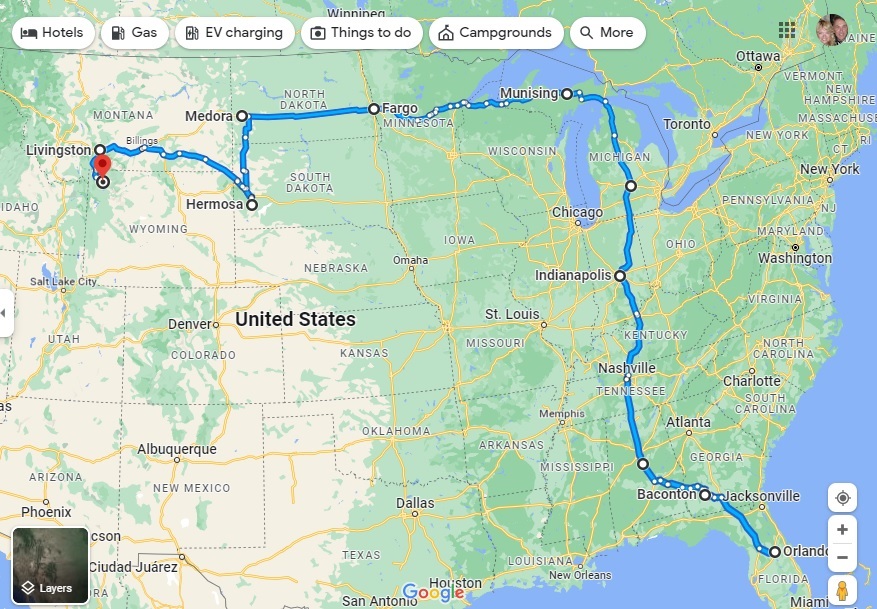
We had snagged a four-night reservation at the Lake Five RV Resort well in advance, knowing how popular Glacier NP is these days, so we were right on the doorstep of the park’s west entrance (and there are only really two ways to see Glacier, from the east or west roads).
The park was beautifully situated and we were able to get set up and then visit Glacier NP’s visitor center, taking the (short) scenic drive along Camas Road, and spending time in the delightful Apgar Visitor Center and Village, which is the heart of the park’s western side.
Just a week out from our arrival, we were able to snag a seat for Simon on the Xanterra Red Bus Tour from Apgar Visitor Center to the Logan Pass – the passage from west to east across the stunning Lewis range of the Rocky Mountains – but we were going to have to wing it for the rest of our four-day stay.
What we hadn’t counted on was the fact that there really isn’t a lot to do and see outside the West entrance to the park. There are no other major scenic drives beyond the park’s boundaries – other than the hilly, winding drive in from the town of Browning, which showcases the southern edge of the Lewis range and which we had already seen in reaching West Glacier.
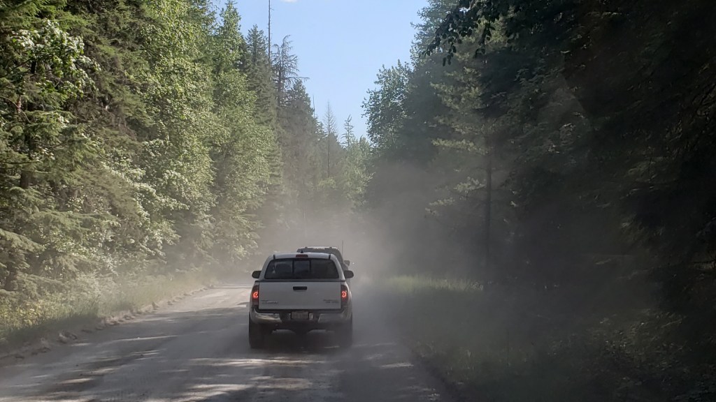
There was also major reconstruction under way of the 10-mile stretch of road along Lake McDonald from the Visitor Center to the lower end of Going-to-the-Sun Road. Not only had the usual paved road been ripped up for replacement, leaving a crude, pitted dirt track in its place, the construction crew also seemed to have abandoned any attempt to keep down the clouds of dust in the afternoon, making it 10 miles of driving torture, especially with a low-slung car like Nippy.
To put it mildly, this was a shocking state of affairs for any park, let alone one of the NPS showcase parks, and to say it was inhibiting was a major understatement. We abandoned the road at the Lake McDonald Lodge, and limped back to the Visitor Center.
This left Simon’s trip on Going-to-the-Sun Road as our lone highlight of the visit. It turned out to be a pretty memorable highlight.
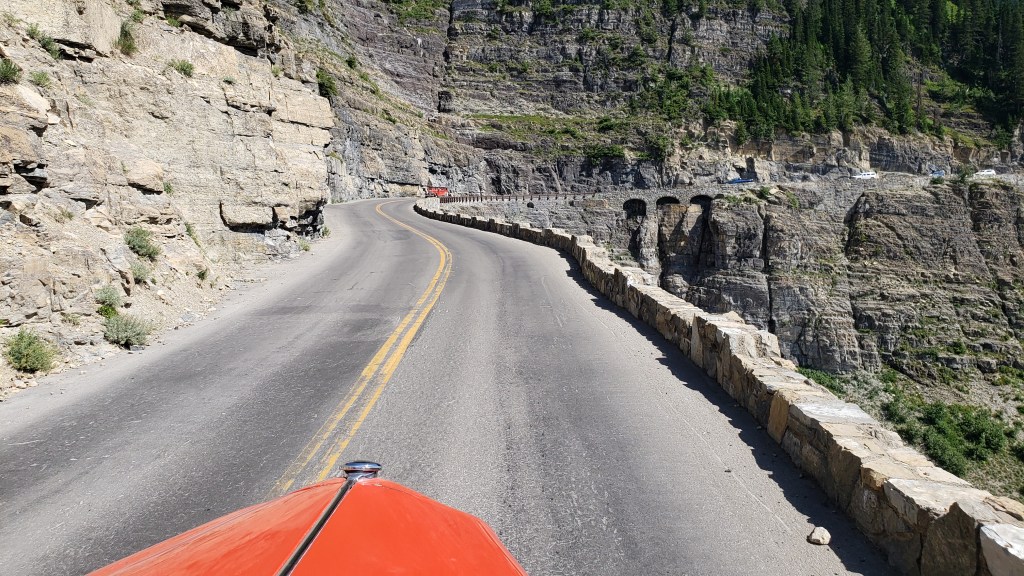
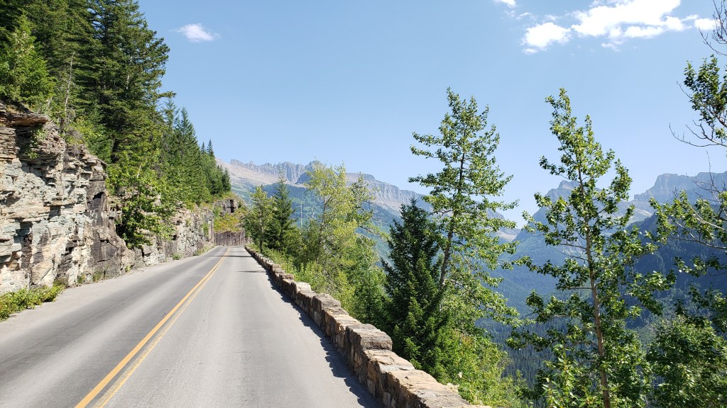
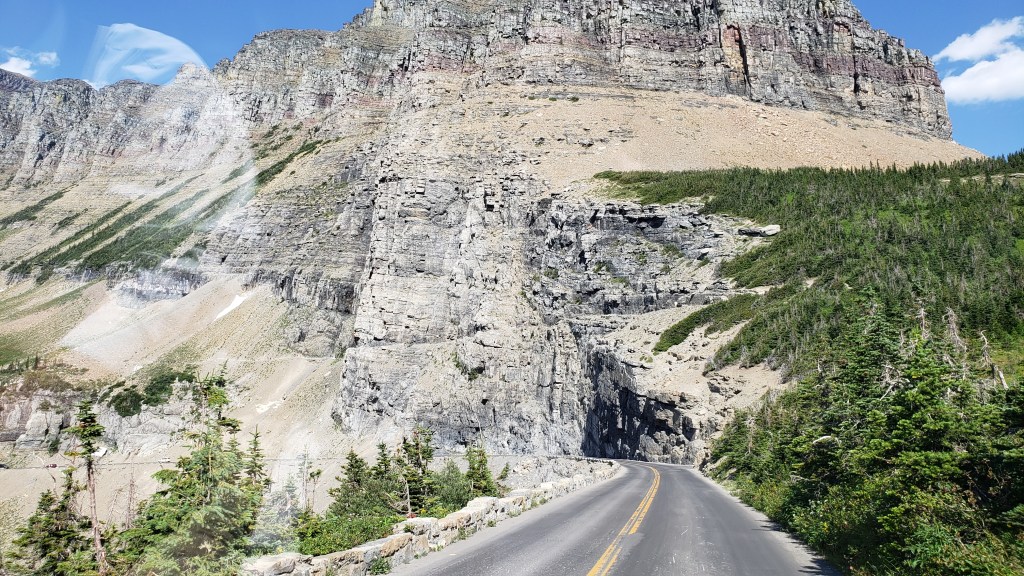
Now, GTTS Road is aptly named, albeit it isn’t quite what you think. It is actually named for the 9,647ft Going-to-the-Sun Mountain, the sacred peak of the Blackfeet Indians, and the rather tortuous translation of their word for it is actually “The-Face-of-Sour-Spirit-Who-Went-Back-to-The-Sun-After-His-Work-Was-Done Mountain.” More aptly, for first-time visitors to the road, it merely feels like you are going to the sun, such is the precarious nature of the precipitous passage up to the 6,646ft mountain pass.
The road dates back to 1932, when it was opened after an 11-year construction process that cost the lives of three workers (how it wasn’t any more is one of the minor miracles of the project). It wasn’t fully paved until 1956, and is one of the hardest routes in America to reopen after each winter, such is the nature of its extreme inaccessibility. Put simply, this road is scratched into the side of a near-vertical mountain wall with all the seeming permanence of an Etch-a-Sketch. How the engineers conceived it, let alone built it, absolutely boggles the mind.
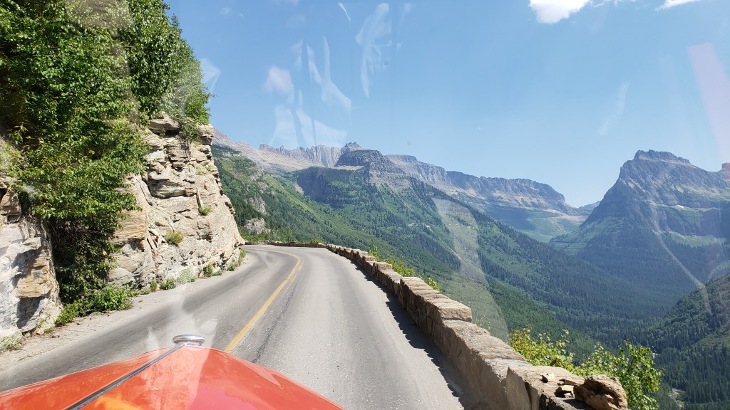
But there it is – the only way to cross Glacier NP, on a winding, sketchy, winter-worn stretch of “road” that wouldn’t earn that designation in any other place on Earth.
Oh, and the iconic Red Bus vehicles – nicknamed the Rubies of the Rockies – that take you there (and back), are almost 90 years old. Really. OK, so they have been modified with modern engines, transmissions, and braking systems, but the basic vehicle was introduced in 1935 and each has chalked up around 200,000 miles since then.
The maximum length for all private vehicles is 21ft. The Red Buses are 25ft long. Yup. Go figure.
So, the basic equation is:
Rickety Road + Outrageous Drop + 90-Year-Old Over-Long Vehicle – New Engine = A Hair-Raising Experience for All Concerned (especially Susan waiting back at the Visitor Center, praying for my safe return).
(It should be added, however, that each vehicle has a 100 percent safety record throughout all those years and miles, and each driver is a specialist)
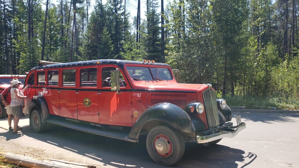
The journey from the Visitor Center to Logan Pass, and back, takes almost 3.5 hours. It reaches a top speed of a daring 45mph, and just 20mph on the seriously scary bits. Two red buses can pass each other on that cliff-edge monstrosity. With about six inches to spare. So, absolutely no worries for the passengers, especially Simon in the front seat next to the driver, with the grandstand view 3,300ft straight down the mountainside.
The first part of the journey is pretty gentle, through impressive cedar forest, alongside Avalanche Creek (nothing inhibiting in that name, either) and past several suitably scenic picnic areas. Then it reaches The Loop.
This is the most critical feature of the entire Road, the only serious hairpin bend on the whole, implausible 50-mile route. It is the engineering pivot that allows the roadway to cling to its precipitous perch and provide access all the way to Logan Pass, which adds a resounding wide alpine plateau for a sizeable visitor center of its own, plus a variety of hiking trails which vary from gentle to “You’ve Got To Be Joking” (the latter for the Highline Trail, which is barely 4ft wide in parts and equally precarious, especially when you hear that the wildlife has right of way, and can include both bighorn sheep and black bears. Any takers…?).
But – and this is a seriously substantial adverb – none of that even begins to describe the utter, stonking majesty of this drive. The solidity of the buses, the assurance of the drivers, and the ability Simon has to be blissfully ignorant about the likely terminal nature of any vehicular mishaps make this a journey of total superlatives.
On each side, the mountain ranges seemingly reach up to levels normally reserved for stratospheric aircraft, including the heart-stopping Garden Wall that towers to 9,553ft and is the main conduit for GTTS Road, as well as the demarcation line for the Continental Divide. That’s right, this is where the North American continent is basically split into East and West, albeit that is primarily a geological term and not a regional designation, seeing as Montana is about as Wild West as it gets.
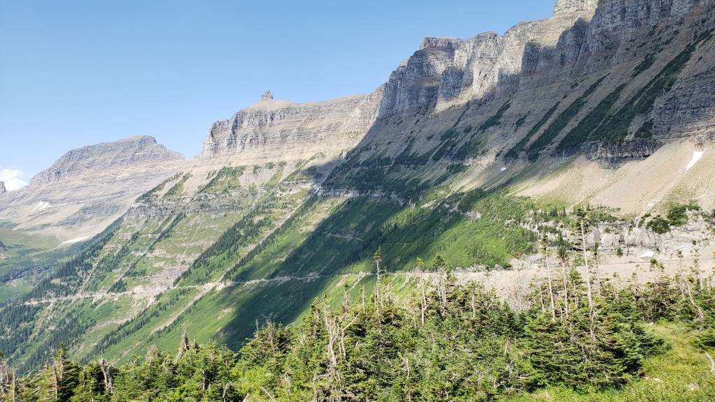
The mountains are studded with breathtaking waterfalls at regular intervals, along with various overlooks to allow drivers to get out and confirm that, yes, that really IS a bugger of a long way down, and “Don’t look now Ethel, but the car brakes are over-heating.”
Seriously, driving these buses up there is something approaching an art form, and sometimes you’re not sure whether to gape at the mountain scenery or the driver’s nonchalant style as they narrate the full story of the Road and everything connected with it.
And that’s it. We comfortably made it there and back, our open-top vehicle providing the best possible viewpoint of the entire Glacier NP, along with regular stops when, on the command “Prairie Dogs Up!,” our 18 passengers all stood up through the open lattice-work of the bus to take photos and marvel at the increasingly insane drop on one side.

It was an experience of the utmost refinement and beauty, a combination of Evel Knievel and Bob Ross, with a dash of Errol Flynn thrown in for good measure. It called for extreme belief in the person behind the wheel, and a cavalier disregard for normal road safety. And it was totally, utterly, mind-blowingly brilliant.
And I’d do it again in a heartbeat.