The fabulous ICE! exhibit at the Gaylord Palms Resort
We always say there is a lot more to Orlando than just the theme parks, as good as they are. And that is especially true for the Holiday season here in Central Florida. There are several dozen Christmas celebrations that all offer wonderful experiences that owe nothing to Mickey and Co, hence we made it the subject for our latest blog for AttractionsTickets.com:
While it’s still barely half-past October, and we haven’t had Halloween yet, let alone Thanksgiving, it is also the case that Orlando is busily gearing up for its busiest time of the year – the Holidays! That’s right, the big Christmas festive season is almost upon us, and that’s the cue for us to set up all the excitement in store in our latest blog for AttractionTickets.com, especially with our UK visitors in store. It all starts on November 2 and there is even more to look forward to than ever before. Don’t believe us? Check out the blog here: https://www.attractiontickets.com/en/latest-news/orlando/walt-disney-world-tickets/lets-go-christmas-crackers
Florida and Orlando have been in the international headlines for major hurricane events in the past few weeks, but that shouldn’t be a major deterrent for our visitors. We discuss why in our latest blog for AttractionTickets.com:
Time goes slow when you’re faced with a major, life-threatening hurricane. With Hurricane Milton churning a destructive path directly towards Florida, the hours take on a slow-motion effect that elongates the temporal nature of things. In short, minutes feel like hours, and hours an eternity.
For three full days, we kept a watching brief – on seven different TV channels! – as what was originally an area with just a “40 per cent chance” of developing into a tropical system flared up in dramatic fashion. With a speed that stunned meteorologists on all seven stations, Milton became a Goliath of the Gulf, a deadly mass of wind and rain.
Its steady move across the super-heated waters of the Gulf of Mexico became a mesmerizing fixation, from Category One to Category “HOW big?” with an inexorable menace. We were on first-name terms with a monster.
Each day, we were told how unusual it was for a hurricane to be barreling due east into the Sunshine State, feeding on the climate-enhanced unseasonal warmth. Each day we learned more about the mechanics and terminology of tropical storms. And each day we considered the options in our tree-lined avenue just northwest of Orlando. Should we stay or should we go?
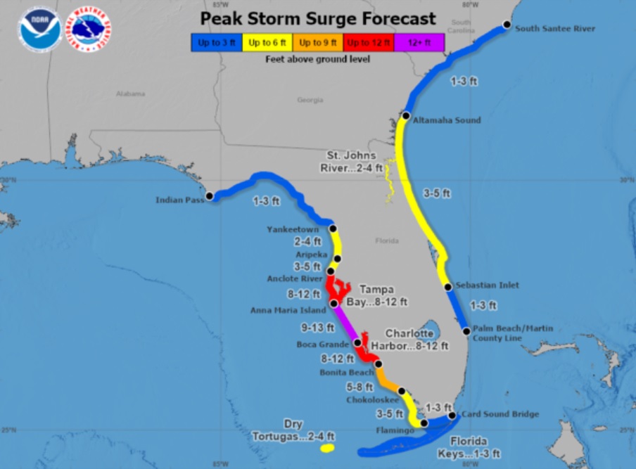
Over on the coast at one of our go-to beach destinations of St Pete Beach, we heard the Mayor of Tampa broadcasting the bald, grim message of “If you stay, you will die.” She also added: “If you’re in a single-story house and we get a 15ft surge, which means that water comes in immediately, there’s nowhere to go. That home that you’re in ultimately will be a coffin.” They definitely weren’t sugar-coating anything. The storm surge associated with Milton promised to be record-breaking and life-taking, and “unsurvivable” became the word of the day, every day.
A full 110 miles inland, the storm surge was not our concern, albeit we viewed the threats to places we loved, such as Anna Maria Island, Longboat Key and Sarasota, with utter horror. Fresh from the widespread coastal devastation of Helene, no-one was in any doubt of what a direct hit would achieve after the extended ravages of the September hurricane.
But, away from the coast, our concerns were more about the effects of continuous hurricane-force winds on the ranks of the 50ft live oak trees dotted along the front yards of each house in the neighborhood. Oh, and tornados.
Yes, we had been fore-warned over and over again – from 20 years of hurricane seasons – that the storm, once ashore, was likely to generate the destructive forces of EF2’s, the small-scale but utterly devastating side-effects of the big storms; totally unpredictable and completely random. Tornados are the really scary thing about hurricanes, and the idea of one suddenly arriving in the middle of the night is the stuff of genuine nightmares.
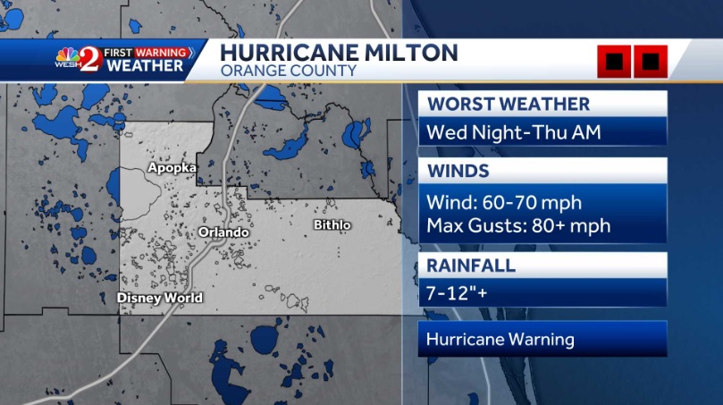
The odds were still in our favor, though. Northwest Orange County stayed consistently on the fringe of the main predicted path. We might get gusts of 80mph, but sustained winds would be “only” in the 60s. It was, in theory, a survivable level of force. True, we also faced up to a foot or more of torrential rain, the kind that comes down in massive sheets at up to three inches an hour, but, with our sub-division on a slope, and two enormous retention ponds to handle the overflow at the bottom of the street, that wasn’t a prime concern.
Therefore we weighed up the odds day by day, and stayed put. In truth, there was really nowhere safe within a few hours’ drive that we could bug out to. The – thankfully – mass exodus from the coast quickly filled up the hotels and motels of north Florida (where there were still places open after Helene), while many from the southwest headed east across Alligator Alley for the presumed sanctuary of Miami, which was just about the only location in south Florida that looked likely to escape the worst ravages of Milton.
Ah, Milton, what an inopportune name. The 17th century British poet of that name never made any mention of hurricanes that we know of, but his most famous work, Paradise Lost, was the kind of harbinger of doom that we could have done without. Our little patio bore rustic signage that insisted “Welcome to our piece of Paradise.” The unintentional irony of Milton’s poem was truly supreme.
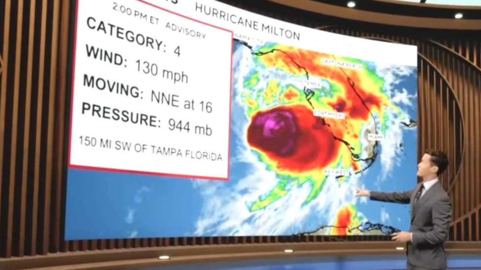
October 9 dawned much as its two predecessors had, overcast and drizzly. The TV stations – each of WFTV 9 Central Florida, Channel 13 Tampa Bay, Accuweather, Weather Nation, Fox Weather, CBS Miami and ABC News Live in turn – all told the same, looming story. Milton was still tracking steadily northeast, dropping from a Cat 5 to Cat 4 but with a widening stormfront as it closed in on land.
There was the possibility of wind shear and dryer air feeding in, though, which provided hope of a late lessening of Milton’s intensity. Wind shear – the enemy of all major storms – was one of the terms we had come to have an intimate understanding of thanks to the meteorological outpourings of the previous days. We cheered for wind shear and rooted for dry air as the possible twin saviors of the state.
Neither force had any appreciable effect on Milton’s forward march, though. As noon passed, the localized rain dried up for an hour, a seeming olive branch for our location from the weather gods. Not so on the coast. The weather radar showed thick, angry orange-red bands of monsoon-like rain, and an increasing smattering of tornado warnings for much of east coast Florida, while those ever-perky meteorologists talked of “tornadic supercells,” “areas of inundation,” “mandatory evacuations,” and “high-tide cycles” (which, apparently, go hand in hand with “record storm surge”).
And still the time crawled on. At 1:00pm it felt like we’d already been awake all day, held in a state of stasis by the oncoming Armageddon. We were getting wind gusts of around 15mph, but nothing to seriously disturb the foliage, and certainly nothing to make us second-guess our decision to stay. Yet.
At 1:05pm we had our first Tornado Watch alarm on the weather radio, a little gadget that makes up for the fact that Florida doesn’t have tornado sirens like the states to the north that experience more – and bigger – tornados as a matter of course. The radio warning would wake the dead, let alone anyone sleeping, hence we don’t expect to get much shut-eye tonight. A Tornado Watch is only an indication that the conditions are ripe for tornados to form. If we get a Tornado Warning, it’s time to hunker down. At 1:20pm, there was a Tornado Warning for Polk County, 70 miles south of us. And then two. And then four. After 30 warnings, we unplugged the radio. You can only listen to the same warning a few times before it drives you plum nutty.
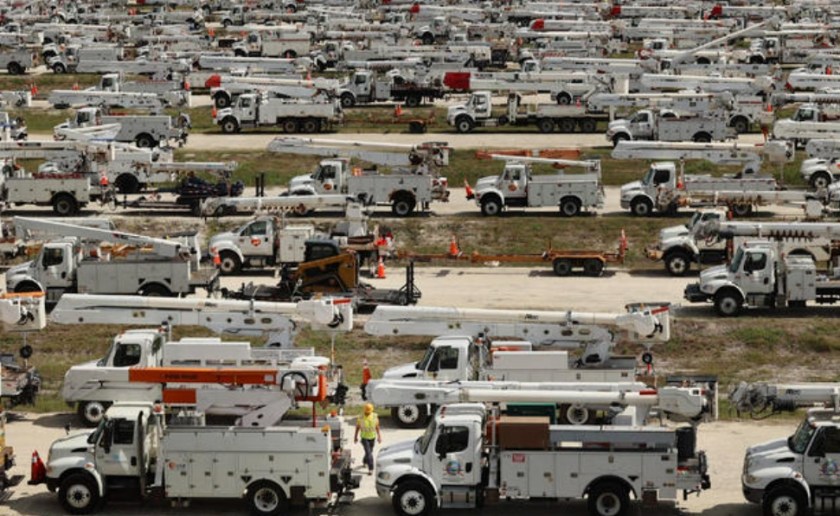
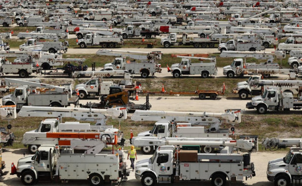
As part of every hurricane preparedness build-up, there are now hundreds of electrical repair crews, all waiting to see exactly where they will be needed
Oh, and before we go any further, for anyone wondering why we don’t just hunker down in the basement against the possibility of an EF2, it’s because there ARE no basements in Florida. None. Here, on what is basically a narrow strip of alluvial sand that sticks out into the sea, if you tried to dig one, you’d have an indoor swimming pool instead of a basement.
At 1:25pm, the first heavy rain arrived. Milton itself was still a good 300 miles away but those outer bands sweeping across the southern half of the state were now starting to stretch their flood-inducing tentacles well to the north, albeit in sporadic bursts.
On local station WFTV, the two main meteorologists were fast working themselves into a frenzy keeping up with a multitude of tornado warnings popping up through south and east-coast Florida and steadily working their way north. Within half an hour, they were juggling with a dozen or more warnings, each one moving steadily closer to Orange County and Metro Orlando.
The word that kept popping up was “Unusual.” It was “unusual” to see such strong tornado indications from the outer bands of a hurricane in October. It was “unusual” to see them on the ground longer than a couple of minutes. And it was “unusual” to be seeing so many in such a short space of time. For the deadly Hurricane Ian in 2022, there had been a round dozen confirmed tornados in Florida in total. Now, we had potentially more than 12 in just a few hours.
Of course, by “unusual” they meant “screamingly extreme and insanely dangerous.” They were just being polite. By 3:30pm, we had the first tornado warning for Orange County, although, happily, it was way over in the rural southeast corner of the county, away from any major population centers. But, with Milton still at least five hours away from landfall, it was a sobering burst of tornadic torment. This, too, was “unusual.” Sadly, for at least six people in the Port St Lucie area, it was tragically fatal, caught by the spawn of Milton in an extraordinary and unforeseen outbreak.
The skies started to darken noticeably around 5:00pm, and not just because sunset was approaching (the actual sundown hour was officially listed as 7:02pm). One of the biggest of Milton’s outer bands was passing across Orange County and the dark-grey, rain-filled skies were being pulled across the region like a gigantic sun shade. Lake Nona, the vibrant, high-tech community in south-central Orange virtually disappeared under a particularly angry orange-red blob on the weather radar.
The 5:00pm National Hurricane Center update also gave us an important revision of the storm’s track, for the first time showing it as “probably” coming ashore on or just south of the city of Sarasota, which, if it holds, will be a major relief for a Tampa Bay that had been warned to prepare for a 10-15ft storm surge. Instead, it will be on the flip side of the surge and should escape the kind of ravages that had the mayor giving her dire warnings of death and destruction only a few hours earlier. Beautiful Anna Maria Island may also escape the worst of it, too.
Conversely, Sarasota itself, plus Venice Beach, Englewood, Port Charlotte, Punta Gorda, Fort Myers and the islands of Sanibel and Captiva could all be facing utter ruin from the massive storm surge generated on the southern side of the storm. At this stage, Milton has been fueled by several hundred miles of super-warm Gulf waters, and the evening rendezvous with the Florida coast promises to be apocalyptic for them, possibly even worse than the damage wrought by Ian just two years ago.
By now, we have prepared our little ‘escape room,’ in a corner of the passageway from the lounge into the bedroom. We have hauled a mattress out of the spare room and propped it up ready to jump behind (with some of our essential valuables, documents, phones, flashlights and external hard-drives) in case of a night-time tornado. The bathtubs have been filled with water to use to flush the toilets if the water supply is cut off, and we have a case of bottled water and plenty of fruit and sandwich fixin’s to keep us going if the power also goes out. The fact we are on the underground power grid of the neighboring high school – which is an official evacuation center, and hence has its own back-up generator – is in our favor, though.
At 7:00pm., wind gusts are up to 27mph, but we’ve been told to expect 60-plus during the night, albeit some of the estimates are dropping in light of Milton reaching land a good few hours ahead of the original projected time of midnight to 2:00am, and as a Category 3, not 4. The TV pictures of the Gulf coast are not so heartening, though, while the tornado outbreak to the south and east has the meteorologists scrambling for comparisons. With 17-plus confirmed tornados, it is by far the biggest outbreak the state has ever seen in a day, and there are some eye-popping videos of the twisters crossing main roads, downing power lines and wrecking buildings. This level of tornadic action was definitely NOT on Florida’s pre-hurricane bingo card, and the TV talking heads are at a slight loss to explain this particular extreme. The best they can manage is that the highly-charged outer bands of Milton ran headlong into the wind shear of an advancing cold front descending through the state, leading to this unprecedented spate of tornados.
Rain remains high on the agenda, however, especially in the area immediately north of the eye of the hurricane. The St Petersburg/Tampa area has been warned to expect up to 18 inches of precipitation tonight, with that intense layer of wind-driven cloud also expected to track inland towards us in the Orlando area. Once again, we’re happy to live on an appreciably sloping road, which is most assuredly not the case for most of flat, featureless Orlando.
16 Hours Later…..
We shut down our computers around 9.00pm and hunkered down in front of the TV next to our little “safe space,” alternating the latest news with episodes of The Great British Baking Show to provide some welcome relief from the growing onslaught. The coastal areas looked suitably grim, but it was hard to follow the progress of the hurricane once ashore as the TV stations all wanted to make their reporters the star of the show and, frankly, it became embarrassing watching them venturing out into the wind and rain desperate to prove their ability to defy the weather.
And there was some serious wind and rain. While Milton posiively lashed the coast, it still had plenty left as it moved inland from Siesta Key. By midnight, Orange County was feeling the force, with wind gusts up to 86mph, and sustained winds around 65. Being that bit further to the north, we experienced gusts approaching 80mph and sustained winds at 55-60. And if that sounds just a touch, well, pedestrian, we can certainly attest to no such thing. For fully four hours, the storm positively howled through our neighborhood, ensuring few people got to sleep and we kept casting anxious glances at the rear windows, which seemed to be taking the full brunt of those alarming gusts.
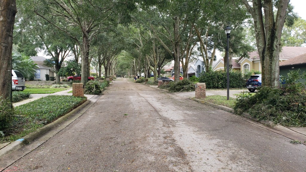
8:00am looking up our street8:00am looking down our street
Surprisingly, there were no further tornado warnings, although our radio kept informing us that “flash-flooding” was occurring in counties across the state. If there was one thing we didn’t need to worry about in our location, it was flooding, so we ended up unplugging the radio again and taking our chances on not needing any further “warnings.” We still had enough to be alarmed about with the way the house creaked and groaned under the constant pressure from the storm, which may have been losing some power but still felt distinctly scary. The occasional muffled thump was also unnerving in the dark, and we wondered what it might be like under a Category 4 storm (like the Great Miami Hurricane of 1926) or even a Cat 5 (like the Florida Keys Labor Day Hurricane of 1935). The thought was absolutely terrifying.
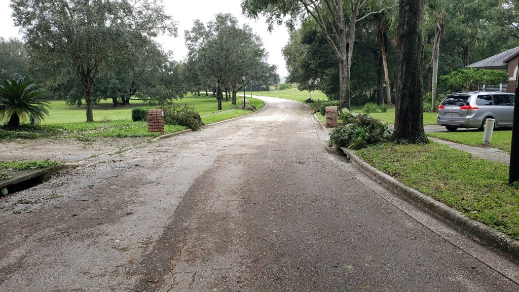
Daylight at 7:25am brought our first real calm since 5:00pm the previous evening. The winds had all but died down, the rain was a mere annoying drizzle, and we could see the malice of Milton. Our street was full of tree debris, mainly leaves and small branches, but with a few more substantial tree limbs mixed in. Our landscape was positively groaning under the weight of 14 inches of rain – which came down like craze-driven sheets at Milton’s height – and we would be able to see, when we ventured to the bottom of the road, that the occasional “thumps” in the dark were a pair of trees that had come down right across the main road out of our sub-division. Amazingly, someone had already been out with a chainsaw, and there was still room for cars to squeeze through.
Driving out of our road, with the two downed trees on the left
The full sub-division had been hit with more trees downed in a handful of places, and general tree debris pretty much lined every road, but there was nothing catastrophic to report, and traffic was able to navigate fairly easily, albeit slightly slower than usual.
More tree debris through the neighborhood
It felt like the whole world had been watching Milton with grim fascination, and there had certainly been plenty to be horrified by, with at least a dozen deaths and large-scale destruction in multiple points along the coast. Flash flooding had been a very real and ongoing concern. Tampa had been spared the full, cataclysmic forecast of doom, but the state’s record outbreak of tornados had added unexpected weight to the disaster-tinged side of the ledger. In short, Milton had lived up to its billing as a monstrous chaos creator, if not quite “the storm of the century” predicted by a few. Unlike Helene, this latest cyclone has not generated the same widespread devastation, but there are places – notably Sarasota, Fort Myers and St Petersburg – that are going to need a lot of help to bounce back.
LOTS of tree debris
In the final analysis, we got a crash course (no pun intended) in hurricane meteorology, a degree-level class for understanding the workings of these monster storms, and we will be even better prepared for the next one. Because we know there will be a Next One, and one after that, and even more besides. Because, despite the efforts of Governor Ron DeSantis and his GOP cronies, climate change will continue to be the biggest issue facing the world, and it cannot just be erased from public discourse and school curriculums. The weather WILL go on being increasingly extreme, and Florida WILL continue to bear the scars. At some point, the public will wise up and Reckless Ron and his ilk will be run out of the state on a rail. And it won’t be a moment too soon.
Looking up our street AFTER a few hours’ of neighborhood clean-upLooking down the street after clean-up